The Erlebnisweg Moselkrampen (Ernst, Bruttig-Fankel, Beilstein, Ellenz-Poltersdorf)
- start: Any: Ernst, Bruttig-Fankel, Beilstein or Ellenz-Poltersdorf (circular hiking trail)
- destination: Any: Ernst, Bruttig-Fankel, Beilstein or Ellenz-Poltersdorf (circular hiking trail)
- medium
- 15,44 km
- 4 hours 50 minutes
- 463 m
- 315 m
- 84 m
- 100 / 100
- 60 / 100
The hiking trail connects the wine towns of Ellenz-Poltersdorf, Ernst, Bruttig-Fankel, and Beilstein on varied paths and trails through the vineyards, fallow land, forest, and the small Mosel villages.
On varied paths and trails through the vineyards, the forest, and the small Mosel villages, the hiker experiences the fauna and flora, the history, and the Mosel culture firsthand.
The themed and information boards, which are repeatedly found along the route with a total length of 15 km and medium difficulty, serve as information media.
Sturdy footwear, surefootedness, and freedom from dizziness are required for hiking, as the path runs along the steep Mosel slope and includes exposed spots that allow great views.
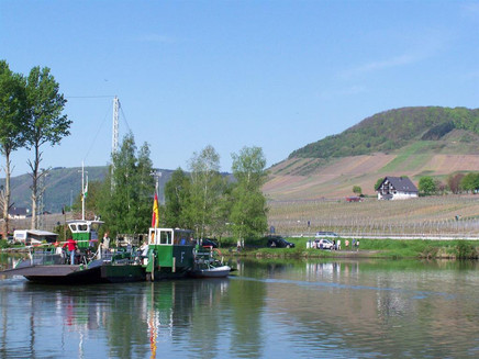
You can start the hike in any of the four towns (Ernst, Ellenz-Poltersdorf, Beilstein, and Bruttig-Fankel), to which you also return through the circular route. Along the way, there is continuous signage and large info boards at the starting points in the towns, making orientation easy on the go. The hiking trail runs on both sides of the Mosel, between which you can switch with the ferry in Beilstein and the bridge at Bruttig.
General information
Directions
You can start the hike in any of the four towns, to which you also return through the circular route. With the ferry in Beilstein, hikers can switch to the other side of the Mosel between Ellenz-Poltersdorf and Beilstein. Between Bruttig-Fankel and Ernst, hikers can cross the Mosel bridge.
Safety Guidelines
After and during rain or snowfall or ice, special caution is required. Walk carefully, wear good footwear, and avoid overestimating yourself and risky trips.
Make sure to bring enough provisions (especially mineral water). However, pay attention to the weight of your backpack. Take breaks, carry a mobile phone (for emergencies), and avoid hiking during thunderstorms.
Equipment
Sturdy footwear and weatherproof clothing are required for the hike.
Tip
Use the ferry between Beilstein and Beilstein – the Sleeping Beauty of the Mosel (from Easter to the end of October daily from 9 am to 12 noon and from 1 pm to 6 pm), respectively the bus line 716 (Ernst + Ellenz-Poltersdorf) and bus line 702 (Beilstein + Bruttig-Fankel).
Getting there
From Koblenz / Cologne direction: Drive on the A 48 motorway up to Kaisersesch. Exit at Kaisersesch onto the state road L 98 towards Cochem.
You reach Bruttig-Fankel and Beilstein if you stay on state road L 98 in Cochem and cross the bridge to the right bank of the Mosel. Follow the Mosel upstream to Bruttig-Fankel and Beilstein.
You reach Ernst, Ellenz, and Poltersdorf if you switch in Cochem to federal road B 49 towards Alf / Trier and follow it upstream along the Mosel.
From Mainz direction: Drive on the A 61 motorway up to Rheinböllen. Exit at Rheinböllen onto the expressway B 50 towards Trier / Hahn airport. Switch at Kirchberg in Hunsrück to federal road B 421 towards Zell / Mosel. At Tellig switch to state road L 98 towards Moritzheim / Grenderich / Senheim.
You reach Beilstein, Bruttig-Fankel, and Ernst if you turn off behind Grenderich to state road L 200 towards Mittelstrimmig and then descend to Beilstein via district road K 42. Downstream on the Mosel, take state road L 98 to Bruttig-Fankel. Cross the bridge behind Bruttig-Fankel to the other side of the Mosel and continue downstream on federal road B 49 to Ernst.
To get to Ellenz-Poltersdorf, stay on state road L 98 from Grenderich up to Senheim. In Senheim, continue on state road L 98 towards Zell and follow the bridge up to the junction at federal road B 49. Here switch to federal road B 49 towards Ellenz-Poltersdorf.
From Trier direction: Drive on the A 1 / A 48 motorway up to Wittlich. Exit at Wittlich onto federal road B 49 towards Zell / Mosel. Stay on federal road B 49 until Nehren is reached via Alf and Bremm.
To get to Ellenz-Poltersdorf and Ernst, continue on federal road B 49 on the left side of the Mosel.
You reach Beilstein and Bruttig-Fankel if you turn off behind Nehren to the bridge of state road L 98 towards Senheim and follow the road along the right Mosel bank.
Parking
Parking is available in all towns directly on the Mosel near the large information boards.
If you drive along the Mosel riverside roads, the arrow signs with the inscription Erlebnis Moselkrampen direct you to the information boards.
Public transit
Ferry between Ellenz-Poltersdorf and Beilstein (from Easter to the end of October daily from 9 am to 12 noon and from 1 pm to 6 pm). Bus line: https://www.vrminfo.de/fahrplanauskunft/
Maps
Hiking map Mosel
Scale 1 : 25,000
ISBN 978-3-89637-256-7
€6.90
Additional Information
Tourist Information Ferienland Cochem, Endertplatz 1, 56812 Cochem
Tel.: +49 (0) 2671-6004-0, Fax: +49 (0) 2671-6004-44
E-Mail: info@ferienland-cochem.de
Pavings
- Asphalt Coating (25%)
- Crushed Rock (27%)
- Hiking Trail (18%)
- Path (24%)
- Street (5%)
- Ferry (1%)
Weather
This tour is presented by: Ferienland Cochem, Author: Tourist-Information Ferienland Cochem


