Dream Loop Kasteler Felsenpfad
- start: Car park in front of the Klause, 54441 Kastel-Staadt
- destination: Car park in front of the Klause, 54441 Kastel-Staadt
- medium
- 8,33 km
- 3 hours 30 minutes
- 386 m
- 361 m
- 183 m
- 100 / 100
- 40 / 100
The rock path leads through the high plateau of Kastel-Staadt and is characterized by a unique variety of experiences with historical treasures, from the Celts to the Prussians.
The Kasteler Felsenpfad leads through the rocky high plateau of Kastel-Staadt and is characterized by a unique variety of experiences. The rock path offers, in addition to historical treasures from the Celtic to the Prussian period, a wealth of scenic delights.
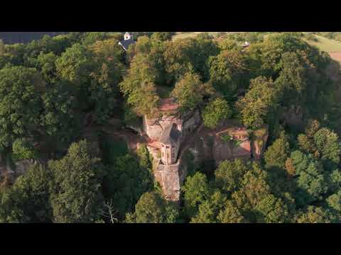
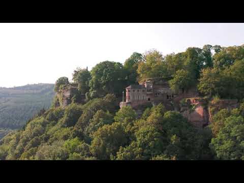
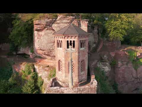
Impressive is the magnificent sandstone rock landscape with towering cliffs and a fantastic panoramic view as well as the idyllic Pinschbach valley. The most beautiful view is offered from the monumental Altfels, which involves a climbing section. For this, you are rewarded with a breathtaking panoramic view of the Saar valley. Other unique rock formations can be found on the route: Roman gate, Round Tower, or the Hedgehog Rock.


General information
Directions
Car park Landesdenkmal Klause - direction Ehrenfriedhof - Elisensitz - Ehrenfriedhof - Klausenportel - Roman theatre - Round Tower - Pilsfels - Altfels - Pinschbach bridge - town centre Kastel - Mariengrotto - Roman gate - car park Klause.
From 1 April to 31 October 2026, the Klause Provincial Monument is open Wednesday to Sunday from 10 a.m. to 4 p.m. In July and August, it is open until 5 p.m. Last admission 30 minutes before closing! Guided tours are offered from 1 April to 31 October 2026 on Wednesdays and Fridays at 10:30 a.m. and on Thursdays at 2:30 p.m. (one tour from 4 May to 18 May 2026).
Safety Guidelines
Almost 80% of the route runs over paths or soft forest ground. Sturdy footwear is recommended. The route is not suitable for prams.
Equipment
Almost 80% of the route runs over paths or soft forest ground. Sturdy footwear is recommended.
Tip
Combine your hike on the Kasteler Felsenpfad dream loop with a visit to the Klause state monument!From 1 April to 31 October 2026, the monument is open Wednesday to Sunday from 10 a.m. to 4 p.m. In July and August, it is open until 5 p.m. Last admission is 30 minutes before closing time! Guided tours are offered from 1 April to 31 October 2026 on Wednesdays and Fridays at 10:30 a.m. and on Thursdays at 2:30 p.m. There are no guided tours from 4 May to 18 May 2026.
Getting there
From Trier, you reach Kastel-Staadt via the B 51 towards Saarburg and further via Trassem (B 407) towards Freudenburg until the exit Kastel-Staadt.
Parking
Free parking in front of the Klause (end of König-Johann-Straße, 54441 Kastel-Staadt).
Public transit
Information on current bus timetables to the stop "Kastel (TR), Kirchstraße" is available at:www.vrt-info.de.
Literature
A free flyer about the Klause and the cultural plateau Kastel-Staadt is available at the tourist information offices in Konz and Saarburg.
Maps
The hiking map "Urlaubsregion Saar-Obermosel" at a scale of 1:35,000 is available for 8.95 € at the tourist information offices in Konz and Saarburg. Or order the map directly in our online brochure shop
Additional Information
Saar-Obermosel-Touristik, Tourist Information Saarburg, Graf-Siegfried-Str. 32, 54439 Saarburg, Tel. 06581-995980
Saar-Obermosel-Touristik, Tourist Information Konz, Saarstr. 1, 54329 Konz, Tel. 06501-6018040
E-mail: info@saar-obermosel.de
Visit our website with exclusive tips and information about the holiday region Saar-Obermosel:
https://www.saar-obermosel.de/
https://www.facebook.com/saarobermosel
https://www.instagram.com/saarobermosel
https://www.youtube.com/channel/UCkcqfebcdiSYLAAj_qIxsBQ
Pavings
- Asphalt Coating (2%)
- Crushed Rock (20%)
- Path (66%)
- Hiking Trail (10%)
- Street (1%)
Weather


This tour is presented by: Saar-Obermosel-Touristik e.V , Author: Saar-Obermosel-Touristik e.V.