Moseltalschanzen side route
- start: Double cross, Bernkastel-Kues, or hiking parking lot Traver Ruh (Graacher Schäferei)
- destination: Traben-Trarbach
- difficult
- 16,33 km
- 5 hours 35 minutes
- 672 m
- 431 m
- 101 m
- 80 / 100
- 80 / 100
A beautiful hiking route with wonderful views and varied sections that connects the two twin towns Bernkastel-Kues and Traben-Trarbach.
A beautiful hike between the medieval town Bernkastel-Kues and the Art Nouveau town Traben-Trarbach.
Elves along the path, hot springs, a bishop's hat, the mysterious Wildstein, and the Graacher Schanzen give the side route a mystical character. Often, narrow paths lead from the town of Traben-Trarbach or the Graacher Schäferei to these distinctive natural and cultural monuments between the Moselle and Kautenbach. Spectacular views are common. Whether from Maria Zill or the Taubenhaus, the roofs of Kues, Trarbach, and Wildstein virtually lie at the hiker's feet. Those who wish to revive the latter after the approximately 17-kilometer-long tour are recommended to visit the Moseltherme of Traben-Trarbach/ Bad Wildstein. The hot thermal water relaxes and contributes to an overall wellness experience. The thermal bath parking lot is also suitable as a starting point for the side route.


General information
Directions
From the double cross at the fairy tale hotel in the old town of Bernkastel, a connecting path leads to the Moselsteig side route "Moseltalschanzen" (which is initially identical to the start of Moselsteig stage 11, or also follows the signage of the "Bernkasteler Bärensteig"). From the small bridge over the Kallenfelsbach, about 1.4 kilometers upstream, the signage of the "Moseltalschanzen" begins with signposts and corresponding markings.
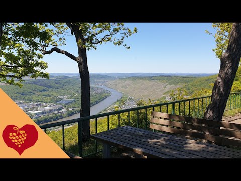
Clockwise, the route then continues along a forest path to the viewpoint "Maria Zill." In good weather, benches invite you to take a break here; in bad weather, you walk about 200 meters further and take shelter in a hut. In both places, beautiful views open up along the edge of the slope into the Moselle valley. The path continues through the hillside forest. Soon you cross the Mosel-Camino and reach a paved road after a wet spot that can be crossed on concrete blocks, which leads downhill to the Graacher Schäferei (you can also start the side route from the parking lot "Traver Ruh" below the curve).
We, however, hike uphill through the double curve to then immediately turn onto a path to the "Graacher Schanzen." It goes uphill. Then you cross a wildlife bridge over the new B50 and continue on a narrow path through dry ditches and on small embankments of the "Graacher Schanzen" – a former fortification – further on. The path meets a forest road and leads onto open meadowland. We follow the forest road about 100 meters north, then turn right onto the meadows. Continuing along the young tree population, the wide view can be enjoyed across the meadows. At the end of the clearing, we orient ourselves by the hunting stand, which indicates the direction. We enter the forest and walk zigzag downhill on forest paths towards Traben-Trarbach. In the vineyards above the Art Nouveau town (intermediate destination "Taubenhaus"), we enjoy the panorama. A narrow path then leads further down towards the Moselle, past the Buddha Museum, into the town center.
The path leads us through Moselstraße to the market (Am Markt), and from there through a narrow alley uphill to the Protestant church and pilgrim hostel. Further uphill, we then pass the cemetery as well. An old hollow path follows, then it continues at roughly the same height along the edge of the forest above vineyards. Now we are at Ungsberg. The next intermediate goal is the Mosel thermal bath, which we can see from up here. It goes downhill, first on forest roads, then past a hunting stand on narrow paths to the L 187, a road that leads into the Hunsrück. At the curve of the country road, we turn onto the parking lot of the Moseltherme and then follow the footpath to the thermal bath. Here, at a staircase, we follow a small path that turns left. Over a narrow path almost overgrown into a tunnel, we reach the entrance to the Elfenpfad. Small signs along the way point to special natural forms. Small slate caves, roots, and crooked trees inspire the imagination. They resemble crocodiles, elephants, goats, or snakes. And of course also homes of the elves. Along the Kautenbach valley, the path winds to the "Bischofsmütze," a striking rock formation designated as a natural monument. There we leave the edge of the valley and continue hiking to the shelter, which is located at the former sports field of the Traben-Trarbach district "Kautenbach." After that, it goes uphill on forest roads. The height is reached when we pass under the new B50 bridge again. After the bridge underpass, we keep left and accompany the federal road about 150 meters on the parallel service road. Then signposts announce that two Moselsteig side routes meet here, because the "Bernkasteler Bärensteig" also leads up to this point. The "Moseltalschanzen" leads downhill to the Kallenfelsbach bridge. From there you reach the Moselsteig back into the Bernkastel old town.
Safety Guidelines
No special safety instructions.
Equipment
Sturdy footwear, possibly a jacket, backpack provisions
Tip
Take a good bottle of wine and tasty snacks and enjoy a well-deserved break at the Maria Zill viewpoint.
Getting there
Coming from the B 53, through the wine village of Graach and the vineyards up to the "Graacher Schäferei," high above the Moselle.
Parking
Graacher Schäferei, parking lot "An der Traveer Ruh"
Public transit
Bernkastel-Kues: Taxi Edringer: 06531 - 8149, Taxi Priwitzer: 06531 - 96970, Taxi Reitz: 06531 - 6455
Closest/primary stop: Trarbach, Enkircher Straße
Literature
All hiking trails in the Bernkastel-Kues holiday region are in the WanderGuide. This brochure is available at all tourist information offices of the holiday region. Online: https://www.bernkastel.de/wir-fuer-sie/prospekte-bestellen/prospekte
Maps
WanderGuide - the hiking guide in the Bernkastel-Kues holiday region. With description and map.
Additional Information
Bernkastel-Kues holiday region
Gestade 6
54470 Bernkastel-Kues
Tel.: 06531/500190
Pavings
- Asphalt Coating (2%)
- Street (1%)
- Path (26%)
- Hiking Trail (56%)
- Crushed Rock (5%)
- Unknown (9%)
Weather


This tour is presented by: Ferienland Bernkastel-Kues, Author: Lisa Gerber