Traumpfad Bergschluchtenpfad Ehrenburg
- start: 56332 Brodenbach, near the police station (Niederbach 1)
- destination: 56332 Brodenbach, near the police station (Niederbach 1)
- difficult
- 18,65 km
- 5 hours 30 minutes
- 879 m
- 378 m
- 71 m
- 100 / 100
- 100 / 100
The path leads through magnificent landscapes on the steep slopes of the Mosel, deep rocky gorges and along lively streams. Pure medieval atmosphere is offered by the Ehrenburg, crowned by spectacular views of the Mosel and Mosel valley.
Highlights on the Traumpfad:
- Rock trough Donnerloch
- Teufelslay
- Panoramic view from Schafberg
- Nörtershausen plateau
- wild romantic Ehrenburg


General information
Directions
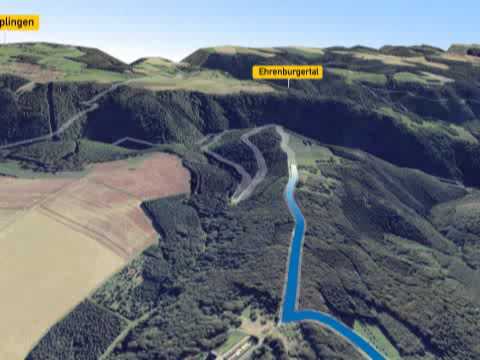
Bergschluchtenpfad Ehrenburg ... through magnificent landscapes on the steep slopes of the Mosel, deep rocky gorges, along lively streams, diving into the Middle Ages at the wild romantic Ehrenburg, crowned by spectacular views of the Mosel and Mosel valley. Highlights Rock trough Donnerloch, Teufelslay, panoramic view from Schafberg, Nörtershausen plateau, wild romantic Ehrenburg Route The Bergschluchtenpfad starts in Brodenbach. The path first leads the hiker into the Brodenbach valley. Flanked by steep slopes, the trail ascends on narrow paths, rewarded with spectacular views. The following section through the Mosel slope leads to the Teufelslay shelter, where the Mosel lies at the hiker's feet. Next is the conquest and circumnavigation of Schafberg, from which there is a panoramic view over the entire region. The path then leads over Nörtershausen back into the Brodenbach valley at the long mountain. The pristine nature, the steep rocks and mysterious caves as well as the Donnerloch with its interplay of rock and gurgling water captivate the hiker. After leaving the valley, the mighty Ehrenburg is the next target in sight. It proudly towers on a rocky spur high above the Ehrbach ridge, creating a real medieval feeling (admission fee required). Before the castle bridge, the trail goes down through the original Ehrenbach valley once more, before after a final ascent the last section on the Sonnenring path leads directly on the steep slope towards the Mosel valley. A narrow serpentine path winds down to the memorial, from where there is a last view of the Mosel. Upon arrival in Brodenbach, it returns to the starting point.
New: The path can now be shortened. The shortcut is signposted.
Safety Guidelines
In some sections surefootedness and a head for heights are required. The path should not be walked on in icy conditions.
General safety instructions:
Safety instructions - safe hiking on the Traumpfade
Hikers want narrow paths, natural trails (over forest floor, grass paths or along streams) and rocky ascents that lead to spectacular views. It is of course essential that such trails are walked with special attention.
What you should pay attention to on your hike:
- Wear weather-appropriate, functional clothing to protect against cold and wet or heat and sun.
- Plan your hike with appropriate breaks and conserve your strength.
- Take enough fluids with you. There are not always refreshment facilities available.
- Please wear hiking shoes suitable for the Traumpfaden that provide sufficient support even on slippery and steep or rocky and uneven paths.
- If you think that certain path sections are not passable for you, you should bypass or turn back. Especially in adverse weather conditions, natural paths can have muddy and slippery sections.
- In autumn, note that fallen leaves can hide unevenness, roots, stones or holes in the path.
- You have to expect such path impairments when hiking.
- Before your hike, check online at https://www.traumpfade.info/traumpfade/wege-status/ whether the Traumpfad you want to hike is possibly closed, whether there are detours, construction work, forestry work or other disturbances.
- Recommended hiking months: April to October.
Difficulty classification
Easy routes
… feature only slight elevation changes and can mostly be completed in half a day regarding distance. They do not require special conditioning or surefootedness. There are no path sections requiring a head for heights. Shorter steeper sections are possible. Depending on the trail format, some sections may be difficult to walk when wet.
Medium routes
… can be managed with normal conditioning. Trail sections may require good surefootedness; therefore sturdy footwear is important, walking sticks can be useful. Some longer and also steeper ascents and descents are possible. Difficult (partly secured) sections are the absolute exception and can usually be avoided by detours. Natural sections may be difficult to walk when wet.
Hard routes
… require very good conditioning and endurance due to length and/or elevation gain. Very good surefootedness is also necessary to manage steep ascents and descents on sometimes demanding paths. Rope-secured sections and/or simple climbing passages requiring a minimum degree of head for heights are possible. Sturdy footwear and walking sticks are important. Paths and exposed sections are often difficult or impossible to walk in wet or wintry conditions.
Equipment
Sturdy footwear is recommended for the route!
Path closures can be found at: https://www.traumpfade.info/traumpfade/wege-status/
Tip
Visiting the Ehrenburg requires admission www.ehrenburg.de
Getting there
B 49 along the Mosel to Brodenbach (A 61 exit Waldesch then via L207 to the Mosel)
56332 Brodenbach, Salzwiese 7
Parking
56332 Brodenbach, Salzwiese 7 (40 parking spaces)
Access: 56332 Brodenbach, Ehrenburg car park
Public transit
Literature
- Traumpfade & Traumpfädchen Volume 1: The 18 best premium circular routes at the Rhine and Mosel, Ulrike Poller & Wolfgang Todt ISBN: 978-3-942779-64-7
- 27 premium circular routes Traumpfade, 10-year anniversary edition Traumpfade, Ulrike Poller & Wolfgang Todt, ISBN: 978-3-942779-43-2
Maps
- Recreation map Mosel "Maifeld and Lower Mosel" (1:25,000), ISBN: 978-3-944620-16-9
Additional Information
Tourist Information Sunny Lower Mosel, Tel.: 02605/8472736, touristik@sonnige-untermosel.de www.sonnige-untermosel.de
Project office Traumpfade, Tel.: 0261/108419, info@traumpfade.info, www.traumpfade.info
Traumpfade app
Traumpfade app for iOS: Download app from iTunes
Traumpfade app for Android: Download app from Google play
Weather


This tour is presented by: Traumpfade im Rhein-Mosel-Eifel-Land, Author: Nicole Pfeifer