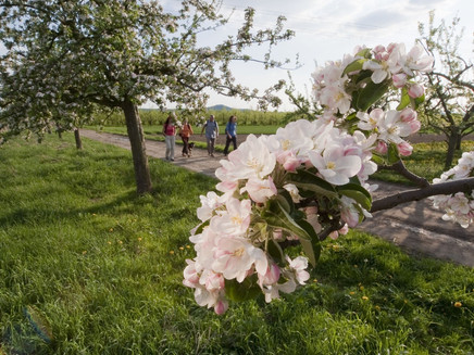
Dream path Streuobstwiesenweg
- start: 56218 Mülheim-Kärlich, Sports field Dalfter (Über den Boschwingerten)
- destination: 56218 Mülheim-Kärlich, Sports field Dalfter (Über den Boschwingerten)
- easy
- 9,04 km
- 3 hours
- 246 m
- 208 m
- 93 m
- 60 / 100
- 20 / 100
Spring awakening during the blossom time of the orchard trees! Throughout the year, fabulous panoramic views and entertaining route guidance inspire. Exciting experience stations complete the dream path.
Highlights on the dream path
- Experience stations with insect hotel, dendrophon, tree guessing and an informative fruit education trail
- Legendary views into the Vulkaneifel, Rhine Valley panorama across the entire Neuwied basin far into the Westerwald
- Orchard trees, meadows and long-forgotten fruit tree varieties along the path
General information
Directions
Immediately after the start at the parking lot by the Dalfter sports field, above Kärlich, the first dreamlike view opens up into the Rhine Valley. Then the path immerses into the splendor of the eastern orchard meadows - in spring a single white-pink sea of blossoms.
Then it goes up to the Kettig barbecue hut with a fine panoramic view. Along the way through a picturesque mix of forest, orchards, and farmland awaits the first experience station: the fruit education trail. Leading through the forest and the Kettig valley, the path takes us down to the Arenz meadow and the Kettig creek. Past gnarled elder trees and more orchard meadows, it goes up to a plateau with a magnificent panoramic view of the Vulkaneifel. The next section over open fields also offers amazing views. Along a row of trees await more experience stations on the path: insect hotel, dendrophon, and the scent didactic. Along an orchard plot, it continues to a small woodland at the edge of the Karl-Heinrich clay pit and into the Niederholz forest. Past a chapel, a grassy path leads back into the orchard landscape. Shortly after, the path leads via several direction changes up to a hill with a magnificent Rhine Valley panorama. At the forest edge, the narrow path runs down to the Dalfter barbecue hut. Through a beech forest, it goes uphill to the viewing platform of the clay pit. After a short, path-like descent through the forest, the starting point is reached.
Safety Guidelines
Safety instructions - safe hiking on the Streuobstwiesenweg
Hikers wish for narrow paths, natural trails (on forest floor, grass paths or along streams) and rocky ascents that lead to spectacular views. Of course, such paths must be walked with special care.
What you should observe during your hike:
- Wear weather-appropriate, practical clothing that protects you from cold and wet or heat and sun.
- Plan your hike with adequate breaks and conserve your energy.
- Carry sufficient fluids with you. Refreshment opportunities are not available everywhere.
- Please wear suitable hiking shoes on the Streuobstwiesenweg that give you enough grip even on slippery and steep or rocky and uneven paths.
- If you think certain sections of the path are not passable for you, you should bypass or turn back. Especially in adverse weather, natural paths can become muddy and slippery.
- In autumn, also be aware that fallen leaves on the ground may hide unevenness, roots, stones, or holes in the path.
- You must expect impairments of this kind when hiking.
- Before your hike, check online at https://www.traumpfade.info/traumpfade/wege-status/ whether the Streuobstwiesenweg might be closed, if detours exist, if path construction work is planned, or if woodcutting or other disturbances are present.
- Recommended hiking months: April to October.
Difficulty classification
Easy routes
... show only slight elevation changes and can mostly be managed in half a day in terms of distance. They do not require special fitness or surefootedness. There are no sections that require freedom from dizziness. Short, steeper sections are possible. Depending on the path format, parts may be difficult to walk in wet weather.
Medium routes
... can be managed well with normal fitness. Path sections may demand good surefootedness, so sturdy footwear is important, hiking sticks may be useful. Some somewhat longer and steeper ascents and descents are possible. Difficult (some secured) sections are a rare exception and can usually be avoided by bypassing. Natural sections can be difficult to walk in wet weather.
Challenging routes
... require very good fitness and endurance due to length and/or elevation to be overcome. Very good surefootedness is also necessary to manage steep ascents and descents on partly demanding paths. Rope-secured sections and/or simple climbing passages that require a minimum of freedom from dizziness are possible. Sturdy footwear and hiking sticks are important. Paths and exposed sections are often difficult or impossible to pass in wet or wintry weather.
Equipment
We recommend suitable hiking shoes for this route.
You can find path closures at: https://www.traumpfade.info/traumpfade/wege-status/
Tip
+++Important notes and tips - especially in spring+++
Blossom forecast:
Full bloom is here! At the same time as the cherry trees, the apple trees and the rapeseed fields, which set yellow accents in the landscape, are now blooming.
Overall, the bloom has accelerated significantly this year due to weather conditions. We currently assume that from mid-April onwards, the blossom magic will decrease. (Status: 10.04.2024)
Dear hiking guests,
especially during blossom time, the dream path Streuobstwiesenweg unfolds its very special charm. Mainly in spring, many hikers from near and far set off for the Streuobstwiesenweg. In spring, additional parking space is available at the adjacent sports field, and a traffic light system regulates the traffic in the access area. Please also observe the current (detour) signs on site.
WE ASK ALL VISITORS
⇒ Observe traffic regulations on site
⇒ Use alternative parking lots if necessary
⇒ Use alternative hiking routes (see tips)
⇒ Respect nature: stay on the path, take your trash/dog waste with you, leave trees undamaged.
Arrival:
PARKING LOTS
⇒ Entry portal at the sports field "Dalfter"
Address: Über den Boschwingerten, 56218 Mülheim-Kärlich
ALTERNATIVE PARKING LOTS
⇒ Förder- und Wohnstätte gGmbH
Important: Designated parking lots ONLY on weekends and holidays
Address: Anne-Frank-Straße 1, 56220 Kettig
Access to Streuobstwiesenweg (Elmar-Hillesheim meadow) 200 m
⇒ Raiffeisenplatz / Burgstraße, district Kärlich
(Construction site warning until 5.4.2024)
Burgstraße, 56218 Mülheim-Kärlich
Access to entry portal 1.2 km
⇒ Parking lot Lukasmühle at the rain retention basin
Address: Bassenheimer Straße, Mülheim-Kärlich (K 88)
Access to Streuobstwiesenweg 1.7 km via MK 6
Total path length: 12.4 km (3.4 km via MK 6 and 9 km dream path)
PUBLIC TRANSPORT ARRIVAL
Bus lines › see: VRM timetable information
330 Neuwied – Weißenthurm – Kettig – Mülheim-Kärlich – Bubenheim – Metternich – Koblenz
331* Bubenheim – Mülheim-Kärlich Gewerbepark – Urmitz station – Mülheim-Kärlich – Bassenheim (* 331 only from/to Urmitz station on Sundays and holidays)
327** Andernach – Weißenthurm – Mülheim-Kärlich – Bubenheim (** 327 only on school days)
332*** Urmitz station – Weißenthurm – Kettig (*** 332 | 336 not on Sundays and holidays)
336*** Weißenthurm – Kettig – Weißenthurm (*** 332 | 336 not on Sundays and holidays)
⇒ Kettig town center
Bus lines: 330, 332*** | Church or 336*** | Mittelweg
Address: Corner Hauptstraße/Breitestraße/Church, 56220 Kettig
Access to Streuobstwiesenweg (fruit education garden, barbecue hut) 900 m or 1.2 km
⇒ Raiffeisenplatz, Mülheim-Kärlich
Bus lines: 330 and 331* | Raiffeisenplatz
Address: Burgstraße, 56218 Mülheim-Kärlich
Access to entry portal "Dalfter" 1.2 km
⇒ Town center, Mülheim-Kärlich
Bus lines: 330 and 331* | Town hall
Address: Corner Poststraße / Kapellenstraße, 56218 Mülheim-Kärlich
Access to Streuobstwiesenweg 1.5 km
⇒ Waldmühle, Mülheim-Kärlich
Bus line: 331* | Mülheim-Kärlich Waldmühle
Address: Waldmühle 1, 56218 Mülheim-Kärlich (district road 88)
Access to Streuobstwiesenweg 1.8 km
Rail arrival
Bus from Mülheim-Kärlich station (district Urmitz station) or from Weißenthurm station
+++ Tips +++
TIP 1 Extension of hiking pleasure:
The regional circular hiking trail MK 6 (Elderberry path) starts in Mülheim-Kärlich at the rain retention basin/Lukasmühle and meets the Streuobstwiesenweg after 1.7 km. Numerous orchard fields are passed along the way. Total length: 12.4 km (3.4 km via MK 6 plus 9 km dream path)
TIP 2 Transfer to alternative hiking & walking circular routes with blossom enjoyment:
Circular Trail MK2 "At the Red Cross"
Here the orchard trees bloom first because it is an "early location."
The trail is 6.4 km long and easy to moderate.
Starting point is the Hümmeroth barbecue hut | Address: Koblenzer Straße, 56218 Mülheim-Kärlich
Circular Trail MK3 - Cherry Blossom Panorama Trail
The trail is 4.1 km long and easy to moderate.
Starting point: Parking lot at the Nass playground | Address: Hoorweiherstraße, 56218 Mülheim-Kärlich
Circular Trail MK6 - Elderberry Path
The trail is 7.8 km long, easy to moderate.
Starting point: Parking lot at the rain retention basin/Lukasmühle
Address: Bassenheimer Straße, 56218 Mülheim-Kärlich
Getting there
B 9 exit Weißenthurm/Mülheim-Kärlich/Kettig - follow K 65 towards Mülheim-Kärlich - 1st right into Weißenthurmer Straße - after about 700 m right into Burgstraße then right again into Hauptstraße - turn left and follow the signage "Dalfter Sports Field"
56218 Mülheim-Kärlich, Sports field Dalfter ("Über den Boschwingerten")
During blossom time:See additional parking lots and paths under Parking
+++ The usual access via Burgstraße is likely closed until 5.4.2024 – a detour is set up. +++
Parking
56218 Mülheim-Kärlich, Sports field Dalfter ("Über den Boschwingerten")
PLEASE USE THE FOLLOWING PARKING LOTS AND PATHWAYS ESPECIALLY DURING BLOSSOM TIME
⇒ Entry portal at the sports field "Dalfter"
Address: "Über den Boschwingerten", 56218 Mülheim-Kärlich
Additional parking space is available at the adjacent sports field in spring.
⇒ Förder- und Wohnstätte gGmbH
Important: Designated parking lots ONLY on weekends and holidays
Address: Anne-Frank-Straße 1, 56220 Kettig
Access to Streuobstwiesenweg (Elmar-Hillesheim meadow) 200 m
⇒ Raiffeisenplatz / Burgstraße, district Kärlich
(Construction site warning until 5.4.2024)
Burgstraße, 56218 Mülheim-Kärlich
Access to entry portal 1.2 km
⇒ Parking lot Lukasmühle at the rain retention basin
Address: Bassenheimer Straße, Mülheim-Kärlich (K 88)
Access to Streuobstwiesenweg 1.7 km via MK 6 Total path length: 12.4 km (3.4 km via MK 6 and 9 km dream path)
Public transit
Destination stop: Kettig, Church
Line 332 Kettig-Weißenthurm-Urmitz Station - Gewerbepark Mülheim-Kärlich
Line 327 Bubenheim-Mülheim-Kärlich-Andernach (only on school days)
Line 330 RegioBus Neuwied-Weißenthurm-Mülheim-Kärlich-Bubenheim
Access to Streuobstwiesenweg (fruit education garden, barbecue hut) 900 m
Destination stop: Mülheim-Kärlich, Raiffeisenplatz
Line 327 Bubenheim-Mülheim-Kärlich-Andernach
Line 330 RegioBus Neuwied-Weißenthurm-Mülheim-Kärlich-Bubenheim
Line 331 RegioBus Bassenheim-Mülheim-Kärlich-Urmitz Station - Gewerbepark Mülheim-Kärlich-Bubenheim
Access to entry portal "Dalfter" 1.2 km
Rail arrival
Train ride to Mülheim-Kärlich (formerly Urmitz station) - transfer to bus line 331 (direction Bassenheim) - exit Mülheim-Kärlich stop Raiffeisenplatz
Train ride to Weißenthurm station - transfer bus line 330 (direction Koblenz) - exit Mülheim-Kärlich stop Raiffeisenplatz
Literature
Dream paths 2 – Beautiful hiking pocket. Premium routes on the Rhine, Mosel and in the Eifel (7 dream paths) Ulrike Poller & Wolfgang Todt ISBN: 978-3-93-43-42-613
Maps
Top. Map "Upper Middle Rhine Valley/Koblenz (1:25,000) ISBN: 978-3-89637-363-2
Additional Information
Association municipality Weißenthurm, Tel.: 02637/913-0, touristik@vgwthurm.de, www.mittelrhein-touristik.com
Rhine-Mosel-Eifel Tourism, Tel.: 0261/108419, info@traumpfade.info, www.traumpfade.info
Dream paths APP
Dream paths app for iOS: Download app on iTunes
Dream paths app for Android: Download app on Google Play
Weather

This tour is presented by: Traumpfade im Rhein-Mosel-Eifel-Land, Author: Nicole Pfeifer

