Traumpfad Wacholderweg
- start: 56729 Langscheid, Wabelsberger Juniper Hut (Neuer Weg 16)
- destination: 56729 Langscheid, Wabelsberger Juniper Hut (Neuer Weg 16)
- medium
- 8,64 km
- 3 hours
- 264 m
- 580 m
- 380 m
- 100 / 100
- 40 / 100
Hiking through primeval nature, juniper heath, and all kinds of forest. Those who want a bit more can combine the Wacholderweg with the Bergheidenweg to make a large circular route.
Highlights on the Traumpfad:
- renatured areas of juniper heath
- wide views across the Eifel
- Nette valley
- Nature reserves Wabelsberg and Büschberg


General information
Directions
The starting point of the Traumpfad is the Wabelsberger Juniper Hut on the upper edge of the village of Langscheid. Through a beautiful heathland, the route goes around the Wabelsberg with views of the forested summits of the East Eifel. Over the plateau, the path passes Langenfeld with its striking church (Eifeldom). Interrupted again and again by forest sections, it soon ascends as a meadow path to Büschberg. The juniper heath typical for the Vordereifel invites you to take a short break at the beautifully designed rest area. Soon the path enters the forest, where a junction leads to the adjacent Traumpfad "Bergheidenweg." The wide forest path winds downwards, follows a lively brook, and eventually leads into the Nette valley.
Soon it goes a short way uphill again on a grassy path with views over the valley. The path turns into a tall beech forest, leads downwards again towards the Nette, before the final ascent through diverse forest leads back to the Wabelsberger Juniper Hut.
Safety Guidelines
Safety instructions - safe hiking on the Traumpfade
Hikers expect narrow paths, natural trails (over forest floor, grass paths or along streams), and rocky ascents leading to spectacular views. It is self-evident that such paths must be walked with special attention.
What you should consider on your hike:
- Wear weather-appropriate, functional clothing that protects you from cold and wet or heat and sun.
- Plan your hike with adequate breaks and use your strength sparingly.
- Bring sufficient fluids. There are not always places to eat or drink available.
- Please wear appropriate hiking shoes on the Traumpfade that provide sufficient grip even on slippery, steep, rocky, and uneven paths.
- If you consider certain path sections impassable for you, you should bypass or turn back. Especially under adverse weather conditions, natural paths may be muddy and slippery.
- In autumn, be aware that leaves on the ground can hide unevenness, roots, stones, or holes in the path.
- You must expect such path impairments when hiking.
- Check the internet before your hike at https://www.traumpfade.info/traumpfade/wege-status/ to see if your Traumpfad is closed, if detours are in place, if path construction or forestry work is planned, or if other disturbances exist.
- Recommended hiking months: April to October.
Difficulty classification
Easy routes
... have only slight altitude differences and are mostly manageable in half a day in terms of distance. They do not demand special fitness or sure-footedness. There are no sections requiring a head for heights. Short steeper sections are possible. Depending on the path format, parts may be difficult to walk when wet.
Medium routes
... are manageable with normal fitness. Path-like sections may require good sure-footedness, so sturdy footwear is important; hiking poles can be useful. Some longer and steeper ascents and descents are possible. Difficult (partly secured) passages are the absolute exception and can usually be avoided by detours. Natural sections can be difficult to walk when wet.
Difficult routes
... require very good fitness and endurance due to length and/or altitude meters to overcome. Very good sure-footedness is necessary to manage steep ascents and descents on partly demanding paths. Roped sections and/or simple climbing passages, which require a minimum degree of head for heights, are possible. Sturdy footwear and hiking poles are important. Paths and exposed sections are often difficult or impossible to walk when wet or in winter weather.
Equipment
Sturdy footwear is recommended for the route!
Information on path closures can be found at: https://www.traumpfade.info/traumpfade/wege-status/
Tip
+++ Due to fallen trees and forestry work, it is currently unfortunately not possible to traverse the officially signed connecting path between the Traumpfade Bergheidenweg and Wacholderweg unhindered. However, connection between the two Traumpfade is still possible via a connecting path through Netterhöfe! +++ (Status: 07.10.2024)
Getting there
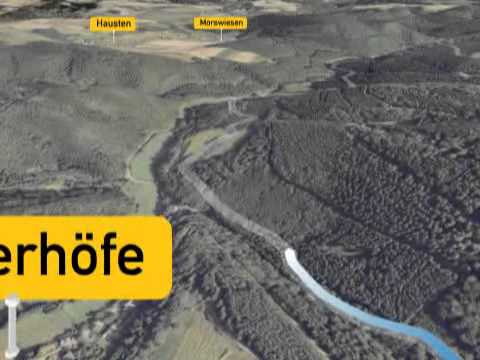
A 61 exit Wehr/Nürburgring - B 412 direction Weibern - village center of Weibern direction Mayen - behind Hausten/Morswiesen right towards Langscheid
56729 Langscheid, Wabelsberger Juniper Hut (Neuer Weg 16)
Parking
56729 Langscheid, Wabelsberger Juniper Hut (Neuer Weg 16)
Others: 56729 Arft, village center
Public transit
Destination stop: Netterhöfe junction.
Line 820 Adenau - Hohe Acht - Hohenleimbach - Kempenich
Literature
- Traumpfade & Traumpfädchen Volume 2: The 19 best premium circular hikes in the Vordereifel, Ulrike Poller & Wolfgang Todt ISBN: 978-3-934342-61-3
- 27 premium circular routes Traumpfade, anniversary edition 10 years Traumpfade, Ulrike Poller & Wolfgang Todt, ISBN: 978-3-942779-43-2
Maps
- East Eifel with Laacher See region hiking map 1:25,000 ISBN: 978-3-921805-63-3
Additional Information
Tourism Office Vordereifel, Tel.: 02651/800995, tourismus@vordereifel.de, www.naturerlebnis-vordereifel.de
Project Office Traumpfade, Tel.: 0261/108419, info@traumpfade.info, www.traumpfade.info
Traumpfade app
Traumpfade app for iOS: Download app from iTunes
Traumpfade app for Android: Download app from Google Play
Pavings
- Path (74%)
- Asphalt Coating (4%)
- Hiking Trail (22%)
Weather


This tour is presented by: Traumpfade im Rhein-Mosel-Eifel-Land, Author: Nicole Pfeifer