Traumpfädchen Löfer Rabenlaypfad
- start: 56332 Löf, sports field (In der Mark 17) - access route to the start portal (350 m) is marked
- destination: 56332 Löf, sports field
- medium
- 4,72 km
- 2 hours
- 158 m
- 232 m
- 128 m
- 80 / 100
- 60 / 100
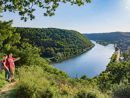
Through wide fields, shady forests, and striking rock formations, the Traumpfädchen leads in an adventurous up and down to the Rabenlay. Highlights include panoramic views of the Mosel valley with occasional views of Ehrenburg and Burg Thurant.
Highlights of the Traumpfädchen
- Alzbachpark
- Mosel panorama at the Rabenlay
- Views of Ehrenburg and Burg Thurant
- Winemaker’s hut with Mosel views
- Mosel town Löf
General information
Directions
At the edge of the forest above Löf, the Löfer Rabenlay trail begins at the shelter in the Alzbachtal. The parking lot is located at the sports field, just 350 m away (the access route is marked).
Immediately, this Traumpfädchen shows that you definitely need some stamina to enjoy the route. Because shortly after the starting point, you climb steeply next to the Alzbach. The Moselsteig briefly joins, but at the height of a water reservoir, it continues alone again. A wooden staircase helps to overcome a steep step before the forest edge comes into view. Once reached, the climb is first conquered.
The logos point left, and while hiking through extensive fields, the view glides relaxedly to the Mosel valley.
After crossing a road, you approach a forest area where you first meet the Traumpfad “Hatzenporter Laysteig”. Both paths follow the forest edge on the left but separate again shortly before the slope edge. The Traumpfädchen turns clearly right downwards, where surefootedness and sturdy footwear prove useful. Eventually, you encounter a path right in the dense slope forest. Rustic atmosphere arises while circling a deeply incised side valley, then the vegetation opens, and at a signpost Traumpfädchen, Traumpfad and Moselsteig merge. Before continuing the route to the left, a restful break is recommended at the nearby winemaker’s hut with a Mosel panorama.
After the scenic break, follow the path through the steep slope. Ignore the side paths to Hatzenport and to the Johanniskirche, as the Rabenlay already beckons ahead! Surefootedness is required again on the way there, but several benches are available for resting and enjoying the magnificent Mosel valley views. After some ups and downs, you finally arrive at the Rabenlay with benches and a hut and are rewarded with a wonderful view.
Reluctantly, you tear yourself away from this idyll and follow the lush hedges gently uphill. When the Traumpfad turns left, the Traumpfädchen Löfer Rabenlaypfad and the Moselsteig turn right towards the nearby K41 with views of Ehrenburg and cross it. Shortly afterward, the route descends right into the forest. After crossing the forest and a significant descent, the Moselsteig leaves the Traumpfädchen, which follows the edge of the meadows. From time to time, you catch a glimpse of Burg Thurant on the other side of the Mosel, then the path enters the forest again at a festival meadow. After a short path section, you return to the starting point of the round. From there, it is only a few steps downhill to the portal at the shelter.
Safety Guidelines
General safety instructions:
Safety instructions – safe hiking on the Traumpfädchen
Hikers want narrow paths, natural paths (over forest floor, grass paths or along streams) and rocky ascents leading to spectacular views. It goes without saying that such paths must be walked with special attention.
What you should consider during your hike:
- Wear weather-appropriate, functional clothing that protects you from cold and wet or heat and sun.
- Plan your hike with adequate breaks and use your strength sparingly.
- Take sufficient fluids with you. Refreshment options are not available everywhere.
- Please wear appropriate hiking boots that give you enough support even on slippery and steep or rocky and uneven paths.
- If you believe at certain path sections that they are not passable for you, you should bypass or turn back. Especially under adverse weather conditions, natural paths can be muddy and slippery.
- Especially in autumn, be aware that fallen leaves on the ground can cover unevenness, roots, stones or holes on the path.
- You must expect path impairments of this kind when hiking.
- Before your hike, check on the internet at https://www.traumpfade.info/traumpfaedchen/wege-status/ whether the Traumpfädchen you want to hike is possibly closed, whether detours are in place, or if construction measures like logging or other disturbances exist.
- Recommended hiking months: April to October.
Equipment
- Between the winemaker’s hut and the Rabenlay hut, the Traumpfädchen runs on a narrow path through the steep slope. Therefore, very good surefootedness, freedom from vertigo, and sturdy footwear are necessary for this section.
- Hiking during ice, snow, or icy conditions is strongly discouraged.
- The Traumpfädchen are not suitable for strollers or walkers.
Find trail closures at: https://www.traumpfade.info/traumpfaedchen/wege-status/
Tip
In Löf and the surrounding area, you will find many winemakers who invite you to a wine tasting.
Getting there
Along the B 416 to Löf - in Löf turn into Bergweg / K 41 towards Münstermaifeld - follow Bergweg for a longer time and turn into the street "In der Mark" at the roundabout - at the end of the street a narrow path leads to the sports field (sign) - drive past the sports field - at the other end of the sports field is the parking lot (footpath to start: 350 m).
Parking lot at the sports field (In der Mark 17)
Parking
56332 Löf, Löf sports field (In der Mark 17 / extension sports field north side) - access route to the start signposted (350 m)
Public transit
Destination stop: Löf, train station (access route signposted 1.1 km)
RB 81 “Moseltal-Bahn” (daily) Koblenz – Trier
Literature
- A beautiful day "traumpfädchen", Ulrike Poller & Wolfgang Todt, ISBN: 978-3-942779-49-4
- Traumpfade & Traumpfädchen Volume 1: The 18 best premium circular hikes on the Rhine and Mosel, Ulrike Poller & Wolfgang Todt ISBN: 978-3-942779-64-7
Maps
- Leisure map Mosel "Maifeld and Lower Mosel" (1:25,000), ISBN: 978-3-944620-16-9
Additional Information
Tourist Information Sunny Lower Mosel, Tel.: 02605/8472736, touristik@sonnige-untermosel.dewww.sonnige-untermosel.de
Project office Traumpfade, Tel.: 0261/108419, info@traumpfade.info, www.traumpfade.info
Traumpfade App
Traumpfade app for iOS: Download app at iTunes
Traumpfade app for Android: Download app at Google Play
Pavings
- Crushed Rock (16%)
- Hiking Trail (49%)
- Path (34%)
- Unknown (1%)
Weather

This tour is presented by: Traumpfade im Rhein-Mosel-Eifel-Land, Author: Nicole Pfeifer


