Moselsteig Side Trail Moseltalschanzen
- start: carpark on the banks of the Moselle, Trarbach district
- destination: carpark on the banks of the Moselle, Trarbach district
- difficult
- 16,23 km
- 6 hours
- 670 m
- 430 m
- 100 m
- 60 / 100
- 100 / 100
Elves, hot springs and relaxing thermal baths.
The Moselsteig Moseltalschanzen side trail combines the two towns of Traben-Trarbach and Bernkastel-Kues as well as a variety of natural and cultural highlights. Outstanding views, unspoilt paths, tributary valleys of the Moselle, the Art Nouveau townscape of Traben-Trarbach, the backdrop of half-timbered houses in Bernkastel-Kues and the eponymous “Graacher Schanzen” (Graach redoubts) await you on this tour. Stretching 17 km, the Moseltalschanzen side trail showcases the great variety of the Moselle landscape. It starts with the Kautenbachtal valley cut deep into the slate, with varied trails that make for a tough but interesting climb to the top. The trails on the top are a great chance to catch your breath. Along the slope edge, the views into the Moselle valley are spectacular and there are plenty of options for rest stops along the way. The “Graacher Schanzen” or Graach redoubts offer the chance to hike through part of the region’s history. The route back downhill to Traben-Trarbach shows just how varied the Moselle tributary valley is: forest, meadows, fruit and, of course, vineyards!
General information
Directions
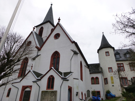
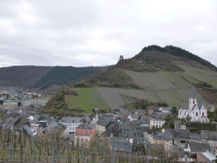
From the carpark on the banks of the Moselle, the trail starts out through the underpass on the B 53 towards the district of Trarbach. Then it continues along Moselstraße past the Mittelmosel Museum and the townhall towards the Evangelical Church. At the townhall, the route turns off into Kirchgasse. After some steep steps you will find yourself at the forecourt of the church with a beautiful view over the part of the twin town on the right bank of the Moselle. The path continues through a stone-built arch and the remains of the town fortifications. A steep, cobbled path leads past the cemetery into the vineyards. Then the path becomes less steep as it continues down the slope into the valley of the Kautenbach stream, flanked by ancient vineyards. Before following the winding path down, make sure you have a look over the edge of the slope. From the Ungsberg you can enjoy a great view of the Moseltherme thermal baths where you can swim in thermal springs under the open sky – even in winter. Looking up the valley, your eyes are drawn to the “Bischofsmütze” (Bishop's Hat) rock formation: the next stop on the Moselsteig side trail. The trail continues along old vineyard paths between vines and slate walls on a steep downhill into the Kautenbachtal valley. After crossing the road, the trail leads uphill to the entrance area of the thermal springs. The next section of the route leads via the Elfenweg trail into the “Trarbacher Schweiz”, one of eight “Schweizen” or “Switzerlands” on the Moselle, named for their natural beauty. The trails and paths wind along the rocky slope, undulating as they go. After a tributary valley featuring the “Roten Quelle” or “Red Springs”, the path leads downhill to just outside of Wildstein. Now the trail starts to climb, steeply in some places, to the “Bischofsmütze” or the Bishop’s Hat. The effort is more than worth it when you see the dreamlike paths edged with mosses. The Bischofsmütze rock formation is made from quartz and offers an incredible view into the Kautenbachtal valley. This is a great spot for a rest. The climb is not quite over yet, with another ascent to the mountain hut at the old Wildstein sporting ground. The forest trails that follow give climbers a sweeping view across the Kautenbachtal valley and beyond into the Hunsrück mountains. At the edge of the forest the view towards Longkamp in the south is revealed on the plateau. In the high forest, the route climbs just a little higher until it rejoins the B 50 route. After crossing the road, the trail continues a little further along the route. The trail joins up with the Bärensteig trail, disappearing into the forest and then steeply downhill into the Kallenfelstal valley. The descent ends at a bridge over the stream - where the side trail meets the Moselsteig trail. From there, hikers can embark on the descent towards Bernkastel-Kues via the Moselsteig. Continuing along the side trail and the Moselsteig, hikers will then follow a steep uphill trail through the oak-lined slope towards the next destination, Maria Zill. The trail will get steep again until it branches off at the Horstenkreuz Cross. At the point there is not far to go uphill. The Maria Zill viewpoint is well worth the effort involved in climbing. It boasts a fantastic panorama from Bernkastel and Wehlen to Zeltingen-Rachtig and the Machern monastery. There’s another rest stop opportunity 200 metres further along at the Maria Zill mountain hut; the edge of the slope here offers a magnificent panoramic view too. The side trail and the Moselsteig follow a downhill path into the Kaisergarten. Hikers then cross the damp valley floor using steeping stones before reaching the hikers’ carpark at the Graacher Schäferei, which can also be used as a starting point for the side trail. The side trail and Moselsteig trail separate here. The climb to the Graacher Schanzen includes a section over a road leading to the Traver Kupp viewpoint. The view is right up there with that of the Maria Zill viewpoint. The connecting path leads sharply upwards through the forest. The trail crosses the B50 again over a vegetation-covered bridge. You have now reached the Graacher Schanzen, namesake of the trail. This defence complex was built at the end of the 18th century. This is where the Prussian Army entrenched themselves against French revolutionary forces. The system of trenches and embankments is still clearly recognisable today. The majority of the path leads across an embankment. At 434 m, this is the highest point of the Moselsteig side trail. The edge of the forest is great place to stop for a rest with a view of the Moselle valley and off into the distant Eifel mountains. The descent towards Traben-Trarbach starts through an area of meadows. The trail continues through the forest and downhill over a rocky ridge until it comes to a road. The side trail crosses the little stream Camper Bächelchen. The trail descends gradually down into the vineyards. The steep vine rows belong to the Trarbacher Hühnerberg vineyard, which dates back to roughly the turn of the 20th century. The steep slope faces the south like a theatre, increasing its exposure to the sun. A little further down you will reach the Taubenhaus vineyard with its beautiful rest stop. The Moselsteig side trail finishes on a narrow, cobbled path which opens out onto “Wolfer Weg” road. The original starting point on the banks of the Moselle is only a few steps away.
Equipment
Sturdy hiking footwear
Appropriate weatherproof hiking gear
Tip
The Moselsteig Moseltalschanzen side trail links the two towns of Traben-Trarbach and Bernkastel-Kues. You can join the trail at either of these places. Anyone who does not want to hike the entire circular route (approx. 8 km one way), can return to the start point by boat or bus once they reach Bernkastel-Kues or Traben-Trarbach. Then why not stop off at the restaurant or visit a winegrower in Bernkastel-Kues or Traben-Trarbach for refreshments after the hike? The one in Traben-Trarbach is best suited for relaxation. En route, the Waldschenke mit Herz snack stop (formerly Zur eisernen Weinkarte) is worth a quick detour.
Getting there
Traben-Trarbach, Trarbach district and Bernkastel-Kues: B 53 between Zell (Mosel) and Bernkastel-Kues
Parking
In Traben-Trarbach and Bernkastel-Kues: carpark on the banks of the Moselle
Public transit
The Moselbahn train station in the Traben district (RB 85 every hour from Bullay) is on the other side of the Moselle. The signposted route towards the starting point of the Moselsteig side trail is approx. 1 km.
Literature
Literature (only available in German):
"Seitensprünge Band 2" - 17 Premium-Rundwanderungen von Bernkastel-Kues bis Koblenz von ideemedia
Authors: Ulrike Poller, Wolfgang Todt, Publisher: ideemedia, 160 pages, Format: 11,0 x 16,4 cm, ISBN: 978-3-942779-60-9, 12,95 €
Maps
hiking map Mosel - Ferienland Bernkastel-Kues, 1:25.000, 1. Auflage 2016, ISBN 978-3-944620-05-3
Additional Information
Mosellandtouristik GmbH
Kordelweg 1, 54470 Bernkastel-Kues; Phone: +49 (6531) 97330
www.moselsteig.de
info@moselsteig.de
Tourist-Information Traben-Trarbach
Am Bahnhof 5, 56841 Traben-Trarbach; Phone: +49 (6541) 83980
www.traben-trarbach.de
info@traben-trarbach.de
Mosel-Gäste-Zentrum (Tourist-Information)
Gestade 6, 54470 Bernakstel-Kues; Phone: +49 (6531) 500190
www.bernkastel.de
info@bernkastel.de
Pavings
- Asphalt Coating (8%)
- Hiking Trail (55%)
- Path (29%)
- Crushed Rock (4%)
- Street (1%)
- Unknown (3%)
Weather

This tour is presented by: Mosel. Faszination Urlaub, Author: Mosellandtouristik GmbH


